
Day One
Tallahassee's modest but attractive Regional Airport features a Visitor Center, an Airport Gallery on the main floor with Big Bend artists and subject matter and an Aviation Museum on the second floor. All are in public areas accessible without passing though security gates.
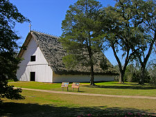
Continue on Capital Circle SW past Blountstown Highway (SR 20) to the next major intersection, which is Tennessee Street (SR 90). Turn right (west). Mission San Luis de Apalache is located at the intersection with Ocala Road. This beautiful 60-acre archaeological park is the site of a 17th century Spanish mission. San Luis contains archaeological evidence of a Spanish fort, church, and residences, as well as an Apalachee Indian council house and village. Interpretive displays and programs bring these early settlers to life. Regular tours are provided on weekdays at noon. The grounds include a reconstructed Apalachee Indian council house (one of the largest historic Native American structures in the southeastern United States, accommodating 2,000-3,000 people) as well as other buildings, gift shop, and bathrooms.
Continuing west along the Byway on SR 20, you will notice that the roadway is bordered by Lake Talquin State Forest. Established in 1977, it consists of 16,326 acres of flatwoods, rolling uplands, swamps, sand hills, and hardwood forests. This forest has the distinction of offering access to two Outstanding Florida Waters, the Ochlockonee River and Lake Talquin.
The trail head and picnic pavilion for Fort Braden Trails is approximately 5 miles west from the turnoff to Silver Lake on SR 20 on the right side of the road. It features restroom and picnic facilities, 9 miles of hiking trails, with 3-5 mile loops, and two equestrian trails. Each trail explores a range of different ecosystems, offering stunning views of Lake Talquin and opportunities to explore steep slopes and ravines which shelter many rare plants more characteristic of the southern Appalachian region.
Coe Landing is off SR 20 and offers a wonderful view of Lake Talquin. A county facility, the landing offers a full service RV center with wireless Internet, electricity, water, hot showers, and dump station, landing, restroom, fishing pier, and picnic shelter.
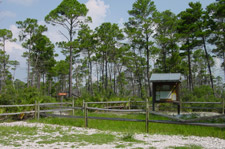
Continue 1.8 miles from Fort Braden Trails on SR 20 to Jack Vause Landing Road, then turn right and follow signs into Lake Talquin State Park's River Bluff Picnic Site. In 1927 the Jackson Bluff Dam was constructed on the Ochlockonee River to produce hydroelectric power. Construction of the dam created Lake Talquin, which is 12,000 acres in size and encompasses 14.5 linear miles of the Ochlockonee River floodplain, offering outstanding recreational opportunities. Visitors can catch Large-Mouth Bass, Bream, Shellcracker, and Speckled Perch or enjoy nature walks, picnicking, boating, and canoeing. Nature lovers will find rolling hills and deep ravines with forests of pines and hardwoods where they may sight Turkeys, Bald Eagles, Ospreys, and Deer. Seepage streams emerge from ravine heads and feed into the lake. These small streams are generally clear and are instrumental in shaping ravine ecosystems over time. On occasion the park may be closed to the public to accommodate private parties. This 554-acre park also has an interpretive trail, fishing pier, boat launch, and restrooms.

Continue on SR 20 for .8 miles to the historic Fort Braden School, which now serves as a Community Center. A plaque describes the history of the fort, which is listed on the National Registry of Historic Places.

The first recreational facility along the river is Pine Creek Landing, approximately 12 miles from the intersection with SR 20. It lies just 1.3 miles to the right (west) from the turnoff on CR 375 and offers a great view of the Ochlockonee River. There are picnic facilities, primitive camping, and a boat launch.

Five miles south of Pine Creek landing is the community of Smith Creek. An old one-room school house is located next to the Volunteer Fire Department. Follow signs to Jack Langston's Fish Camp and Boat Ramp, just to the right off the Byway, to see some original fish camp cabins by the river.
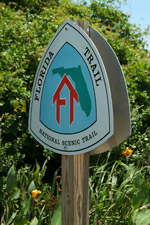
Porter Lake Recreation Area is located in the heart of the National Forest on the banks of the Ochlockonee River. The remote site provides visitors with primitive campsites, fresh artesian well water (hand pump), boating opportunities, picnic tables, pit toilets, hiking trails, and immediate access to fishing waters. In addition, Porter Lake Recreation Area provides parking and trail access to the Florida National Scenic Trail, which leads hikers through Florida's natural wonders as it meanders 1,300 miles across the state. In 1983 the U.S. Congress designated the Florida Trail as part of the National Trails System, making it one of only eight National Scenic Trails.
The next ANF facility you will come to on CR 375 is Mack Landing. It is a fee area, with camping, boat launch, picnic tables, restrooms, and fishing. As you continue southward, the National Forest gives way to gently rolling fields and farms.

Myron B. Hodge City Park is a 35-acre park located on the banks of the pristine Sopchoppy River. The park serves as the location for Sopchoppy's annual July 4th celebration with live music, food, and fireworks. The facility includes camping, restrooms, hot showers, nature trails, boat ramp, fishing dock, boardwalk, gazebo, children's playground, and picnic pavilions. The park grounds also house the historic Ed Whaley log home and Curtis Mill School. Favorite activities include boating, kayaking, swimming, birdwatching, wildlife viewing, and fishing.
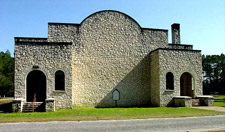
Take Yellow Jacket Street from the center of town to reach the Historic Sopchoppy High School and Gymnasium. A plaque describes the history and architecture of this site, constructed in 1939 in native limestone by Works Progress Administration (WPA) labor. It is listed on the National Register of Historic Places. The auditorium is also the site of the Sopchoppy Opry, which presents monthly concerts of country, gospel, and blue-grass music in the Grand Ole Opry tradition.
Follow signs on Curtis Mill Road to Wood Lake, a facility of the Apalachicola National Forest, which has a boat launch and fishing.
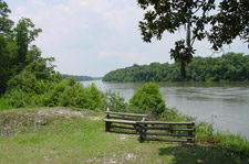
From Ochlockonee River State Park, continue south on US 319 over the Ochlockonee River, leaving Wakulla County and entering St. James Island in Franklin County. At low tide, if you look carefully to your right, you can still see the remains of the Old McIntyre Ferry lying in state partially submerged against the southwest bank of the river. McIntyre was a turn-of-the-century logging town and mid-way stop for the GF&A railroad line from Tallahassee to Carrabelle. You can still see the old trestle at the St. Joe Boat Ramp by turning right (west) on McIntyre Road (a dirt road).

At the first intersection with Rio Vista Road (CR 370), turn left and take a brief side trip, parallel to the river, to the Cow Creek Boat Ramp. If you have a kayak or small boat, you can spend an interesting 45 minutes to a few hours exploring Cow Creek, a beautiful stream that meanders past huge Cypress trees and banks lined with Wild Rice. Also drive slowly to see White Squirrels in yards and trees. White Squirrels were brought to Breakaway Lodge, now a private home on Rio Vista, by its original owner, Fenton Jones, in the 1950s from a small population protected by a farmer in Gadsen County, Florida. They are not albino but leucistic and the trait is dominant because 8 out of 10 squirrels at Breakaway are white. Since then they have spread up and down the Ochlockonee River including the Ochlockonee River State Park. The White Squirrels at the Tallahassee Museum of History and Natural Science are also from this "family." The Breakaway Lodge was a hunting and fishing lodge built in 1938. Many famous personalities stayed there, including Ted Williams, Cab Calloway, and Richard Boone.
From the intersection of Coastal Highway (US 98) and Sopchoppy Highway (US 319), continue west. Down the road 3 miles you will come to the St. James Bay Golf Course on your right. This 18-hole championship course, designated as an Audubon International Sanctuary, is both challenging and beautiful. Facilities include a restaurant and pro shop.
The first creek heading north on SR 65 is Cash Creek with a boat launch, picnic pavilion, and dock on the east side of the road. Get out your cameras. The magnificent views from here and the bridge are well worth the entire drive. The next creeks heading north are Whiskey George (which has a handicapped-accessible landing), Doyle Creek and Landing, then Graham Creek & Landing. The train trestle and tracks along the roadway belong to the Apalachicola Northern Railroad. 16.6 miles from the starting point on Highway 65, the Byway enters the Apalachicola National Forest.
In four miles you will come to a sign on the west side of the road (FR 129) marking the entrance to the Fort Gadsden Historic Site. FR 129 is a graded dirt road that passes through wet savannahs about one mile from the turnoff at SR 65. In spring, these savannahs are in bloom. You can find Pitcher Plants, Orchids, and Sundews with great opportunities for close-up photography. But expect to get your feet wet! Follow FR 129 for 3 miles west to the Historic Site. Called the "Hill of Good Vistas" by the Spanish and "Achackweithle" by Native Americans, this site on the eastern bank of the Apalachicola River—so tranquil in appearance today—was the focus of a series of international conflicts that literally determined the destiny of nations. At various times Prospect Bluff hosted a Spanish settlement, a British Fort, a Negro Fort, and the U.S. Fort Scott and Fort Gadsden. Conflicts involved escaped Negro slaves; Creek, Choctaw, and Seminole Indians; British and American forces; and Confederate and Union troops. This site is a National Historic Landmark and is listed in the National Register of Historic Places.

There are two other distinctive Apalachicola National Forest facilities that you may wish to visit along this route. After returning to the Byway (SR 65), travel 2.5 miles further north to FR 101, a graded dirt road. Both facilities may be accessed from this road. 101-B leads to Hickory Landing with camping, picnic tables, restrooms, drinking water, boat landing, and fishing and hiking trails. 101-A leads to Wright Lake with camping, picnic tables, trailer space and dump station, restrooms, showers, fishing, swimming, hiking, and nature trails. Wright Lake is handicapped-accessible and both facilities have entrance fees.

The Byway ends 2.5 miles to the north at the old town of Sumatra. If you have time, take this side trip to explore more of the Apalachicola National Forest and the Apalachee Savannahs Scenic Byway. In spring and fall the roadway is famous for its magnificent wildflowers. The savannahs are sub-tropical grasslands scattered with Longleaf Pine trees and covered with drought-resistant undergrowth. They form an open landscape where Wiregrass covers the forest floor. Much of the soil is sandy and often wet. Wildflowers such as Orchids, Pitcher Plants, and Sundews flourish, making the savannahs some of the most botanically rich areas in the country.
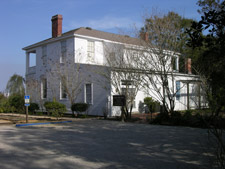
In Apalachicola, continue through town on Market Street to the end of the road and the terminus of the Coastal Trail of the Big Bend Scenic Byway. Along this route you can visit the Chapman Botanical Garden named for Alvin W. Chapman, an internationally known botanist and friend in the early 1800s of Dr. Gorrie, as well as these other facilities: The Orman House State Park is opposite the Garden, behind the War Memorial. The house was built in 1838 by Thomas Orman. The wood for this two-story home was cut to measure near Syracuse, New York, and shipped to Apalachicola by sailing vessel around the Florida Keys, then assembled on the bluff overlooking the broad estuary and bay of the Apalachicola River.

The Chestnut Street Cemetery, established in 1831, is one of the most significant on the Byway. Stop by the Apalachicola Bay Chamber of Commerce and Visitors Center at 122 Commerce Street for brochures and walking maps. Home of "The Official Big Bend Scenic Byway Sandwich," Apalachicola has the only live professional theater on the Byway (the historic Dixie Theatre),a variety of lodgings and B&Bs, restaurants, gas stations, grocery stores, post office, marina and marine supplies, public docks, parks, outfitters and guides, and fast food chains. Another noteworthy stop is the John Gorrie State Park, celebrating the local doctor who pioneered the development of artificial ice-making, refrigeration, and air conditioning.
The St. Vincent National Wildlife Refuge Visitor Center is Iocated in the Harbor Master Building, 479 Market Street. It offers interpretive displays and information on St. Vincent, a remote 12,300-acre barrier island at the west end of Apalachicola Bay. The wildlife refuge contains an 86-acre unit in Franklin County as well as 45-acre Pig Island in St. Joe Bay, Gulf County. St. Vincent is dissected by dune ridges, which are geological records of ancient beaches and fluctuating sea levels over the last 5,000 years. Many of the sand roads follow these ridges extending from east to west the length of the island. The interdune areas vary from freshwater lakes and sloughs to dry upland pine forests. Four miles wide and nine miles long, St. Vincent is larger and wider than most of the northern Gulf Coast barrier islands. Previous owners introduced a variety of exotic wildlife to the island. A population of Sambar Deer, an Elk native to Southeast Asia, still roams the island. In 1990 St. Vincent was selected as one of several southeastern coastal islands for the breeding of endangered Red Wolves. An island shuttle service provides transportation to St. Vincent.
Located at the opposite end of the boat harbor from the St. Vincent's Visitor Center is the Apalachicola National Estuarine Research Reserve Nature Center, containing extensive displays and information on the estuary that includes the river delta bay. Three tanks include indigenous life from the river, bay, and gulf. A short interpretive nature walk winds through a picturesque wetland.
Apalachicola Maritime Museum, located at 103 Water Street, celebrates the maritime history of Apalachicola with displays, an active sailing program, boat building and restoration, and educational programs. Collectively, the activities of the AMM provide a vision into the rich history of the Gulf coastal region and river systems that come together to form the Apalachicola, the largest river in Florida. The museum's centerpiece is the Heritage of Apalachicola, a 58' wooden ketch designed by L. Francis Herreschoff.
Day Two
St. George Island Lighthouse was originally constructed on Cape St. George by Edward Bowden in 1848. It was a conical tower constructed of brick and iron, 74 feet high. It was lighted in 1850 and deactivated in mid-1994. The original lens by Winslow Lewis was fifteen fixed Lewis lamps with sixteen-inch reflectors, which were replaced by a third-order fixed Fresnel lens by Henry Le Paute with a focal plane of 72 feet. The tower collapsed following Hurricane Dennis in 2005, moved to its current location of St. George Island, and painstakingly reconstructed brick-by-brick for public viewing by the lighthouse association.
Marion Millender Site is a lovely shaded picnic area on St. George Sound. It is located in Eastpoint on George Patton Road (SR 30) on the water past several seafood houses. From here it is only a short distance to the St. George Island Bridge Fishing Pier, which is a remnant of the old bridge that was completed in 1965. Left standing on both sides of the Sound, these piers today are popular fishing spots.
Tate's Hell State Forest is located west of the Crooked River Lighthouse on US 98. Pull into the parking lot for High Bluff Coastal Hiking Trail to access this one-mile loop, which features coastal scrub habitat unique to this coastline. The route crosses old sand dunes covered by plants, Scrub Oaks, and isolated groups of Sand Pines, and lower elevations with dense Palmettos, Slash and Longleaf Pine. A picnic table is located at the halfway point and a park bench at the end of the spur trail.
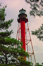
Located on US 98 1.9 miles west of Carrabelle Beach is the Crooked River Lighthouse. Erected in 1895 to replace the Dog Island lighthouse, it is a steel skeletal tower constructed of cement and iron, 103 feet high, with 138 steps. The lens was built in 1894 by Henri La Paute in Paris. Ownership of the tower was transferred to the City of Carrabelle, and subsequently leased to the Carrabelle Lighthouse Association, which has restored the structure and opened the adjacent land, where two lightkeepers' houses once stood, as a public park.
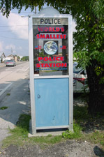
Featured on "Real People," "Ripley's Believe It or Not," and the "Today Show," the World's Smallest Police Station is located in Carrabelle on the north side of US 98 as you drive west. In the early 1960s the police phone was bolted to a building at the corner of US 98 and Tallahassee Street. To avoid problems with tourists making unauthorized long distance calls and protect officers from the elements, the phone was later placed in a booth at its current location. However, the illegal calls continued and eventually the dial was removed from the phone. Vandals later ripped phones from the booth, shot holes through its glass, and knocked it over. A tourist once asked a gas station attendant to help him load it into his vehicle so he could take it back to Tennessee. The original booth is on display in the Carrabelle Chamber of Commerce office.


Carrabelle's Riverwalk along Marine Street offers waterfront pavilions, fishing, state-of-the-art fish cleaning stations, boat launch and docking facilities, as well as restaurants. The Camp Gordon Johnston Museum is located across the street. Dedicated to the heritage of soldiers of World War II, this museum focuses in particular on those who trained here for the D-Day amphibious landings. It includes extensive history of these units as well as a photographic display of the area and life as it existed at the camp. Artifacts are displayed in six rooms: Barracks, Equipment, War, Home Front, Camp Gordon Johnston, and Franklin County Veterans.
Located in St. Teresa on US 98, FSU Marine and Coastal Laboratory was constructed in 1968 to facilitate study of the coastal environment. Facilities include laboratories, classrooms, a modest library, housing, a fleet of small boats, a 47-foot multi-purpose research vessel, diving technology, and other equipment for education and research in the marine environment. The laboratory is open year-round. Its facilities are available for use by Florida State University faculty, staff, and students as well as (by prior arrangement) investigators and educational groups from outside the university. Plans are under way to incorporate a stop on the Byway for the traveling public.
Bald Point State Park borders the south side of Ochlockonee Bay in Franklin County. It is 2.9 miles from the turnoff on US 98 to CR 370. Some of the most picturesque areas along the North Florida Gulf Coast can be found at this park, one of the newest additions to the award-winning Florida Park System. Located on Alligator Point where Ochlockonee Bay meets Apalachee Bay, Bald Point offers a multitude of land and water activities. Coastal marshes, pine flatwoods, and oak thickets foster a diversity of biological communities that make the park a popular destination for birding and wildlife viewing. Every fall, Bald Eagles, other migrating raptors, and Monarch Butterflies are commonly sighted here as they head south for the winter. A surprising site, you might see Black Bears, Sea Turtles, and Alligators sharing the same stretch of beach…watch for tracks!
South of Panacea on Coastal Highway (US 98) is Ochlockonee Bay. The wetland views along this portion of the Byway are stunning. Watch for Bald Eagles, Osprey, and Herons along the roadside ponds. This tranquil bayside community offers fishing supplies, deli food, coastal home rentals at realty offices, RV camping, gas stations, waterfront restaurants, and the Wakulla County Regional Airport with a grass runway for small planes. During the summer airplane rides and skydiving are offered here. At the blinking traffic light before the Ochlockonee Bay Bridge turn right (west) onto Surf Road, which leads some 3.6 miles past private coastal homes to the entrance of another portion of the Panacea Unit of the St. Marks National Wildlife Refuge.

Alternatively, turn left at the blinking traffic light onto Mashes Sands Road to visit the beach, boat launch, and fishing pier at Mashes Sands County Recreational Area. This is a nice place to view Apalachee Bay, watch Dolphins, cast for Mullet and, at low tide, walk the sandbars to see a great variety of shorebirds, including Black Skimmers.
Panacea's working waterfront is just down Rock Landing Road. Located on beautiful Dickerson Bay, Rock Landing has docks for commercial and charter fishing, a waterfront restaurant, boat supply store, boat storage, and launching facilities. Funds have been received to renovate the facility, so some of the services may not be currently available.
Located within the Panacea Unit of the St. Marks National Wildlife Refuge in Panacea, the Otter Lake Recreation Area offers picnic tables and shelters, restrooms, a launching point for small boats with a motor size limit of 10 horse power or less, and lovely views of the lake backed by Cypress trees and moss-draped Oaks.
Another nice stop is Woolley Park, which has a children's playground, walking trail, parking, and fishing pier. Each May the park is the site of the annual Blue Crab and Mighty Mullet Maritime Festivals. Turn left on Mound Street at the south end of the Shops by the Bay center to access the parking lot at Woolley Park. The Big Bend Maritime Center is being developed in the two buildings adjacent to the park and will be open in 2010, with on-water activities, lectures, interpretive displays, and much more. Meanwhile, there is a small but informative "mini-museum" in the Shops by the Bay center.

You can walk directly across the road to visit the Panacea Mineral Springs, which are being restored to their original glory; a replica of the early 1900s hotel at the site is on the drawing board. Founded in 1895, Panacea was named for the healing properties of its many mineral springs. Visitors arrived from far away by buggy and plank road trams drawn by mules to bathe in the springs' curing waters.

As you enter Panacea from Medart, the Wakulla County Welcome Center will be on your left. Perched on pilings overlooking Dickerson Bay, the Center offers sweeping views of the surrounding marshland and coastline. Stop in to look at old photographs, artifacts, artwork, and educational displays; pick up information about area attractions; and talk with the knowledgeable and friendly volunteer staff.
As you drive north from Panacea the first turn on your right is Bottoms Road, leading 2.5 miles through the Refuge along Dickerson Bay and offering fantastic marsh views. This is an excellent birding spot, where you may find large congregations of White Pelicans in winter, Marsh Hawks in the fall, Marsh Wrens, Clapper Rails, and a wide variety of shore birds in spring. In summer you might even spot a Roseate Spoonbill. Birding or not, the view alone is worth the drive. A boat ramp at the end of the road offers fishermen direct access to the Bay. You can also park there and walk along the beach or road. At night Bottoms Road is a great place for star-gazing.
Located on your right as you drive north between Panacea and Medart on US 98 is Skipper Bay Road, a graded dirt road entering the Panacea Unit of the St. Marks National Wildlife Refuge. Roughly 1 mile down this road, you will see a number of large Long-Leaf Pine trees with the distinctive turpentine "cat-face." Some still have the tin drains attached and are the best surviving remnant along the Byway of the important turpentine and naval stores industry that once characterized the area. You can turn around where the road ends at the small bridge. The reason the "Road Closed" sign is posted at the entrance is that the road no longer continues all the way to Skipper Bay.
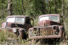
To access the Harvey's Historic Truck Display, turn north on US 319 in Medart toward Crawfordville. This unusual roadside display of several generations of old rusting trucks in an open field is one of the most photographed features along the Byway. It is located 1.8 miles north of the Lake Ellen Church and Cemetery.
Spring Creek, which is accessed off US 98 at the intersection with US 319 in Medart, is an historic fishing village on the banks of Dickerson Bay. The name comes from a first magnitude spring that upwells just off shore. No facilities except for the Spring Creek restaurant.
Medart Recreation Park, on US 98 in Medart, has ball fields, basketball courts, a children's playground, and ample parking. There is no fee. This portion of the Byway is planted with native wildflowers in bloom during spring and fall.
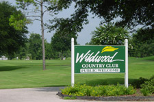
Located on US 98 near Medart, the Wildwood Golf and Country Club features a restaurant, golf shop, and driving range. Its popular 18-hole course is open to the public.
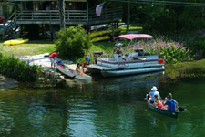
The Wakulla River, which originates at Wakulla Springs, flows south for about ten miles, crossing US 98 before joining the St. Marks River near Fort San Marcos. The crystal clear waters make it a popular place for swimming, boating, and fishing. Whether you explore up stream or down, you will see lots of wildlife including West Indian Manatees, Turtles, Alligators, and a wide variety of birds and plants. Canoe and kayak rentals are available at the southeast side of the US 98 bridge.
Wakulla Beach is accessed by Wakulla Beach Road, located 1.3 miles west of the Wakulla River on US 98. This graded dirt road enters the Wakulla Unit of the St. Marks National Wildlife Refuge. The beach is 3.9 miles down the road, near ruins of an old hotel. There are no public facilities but the solitude and views of Goose Creek Bay and vast seagrass beds are worth the drive.

After the first mile, Wakulla Beach Road passes a trailhead for the Florida National Scenic Trail, which leads hikers through Florida's natural wonders as it meanders 1,300 miles across the state. There is a small parking lot at the trailhead. From there, hike the trail west for about 2 1/2 miles until you reach Shepard's Spring (allow approximately two hours for the round trip plus the time you wish to spend at the spring). This is a beautiful spring surrounded by lush vegetation. The path to the spring is now a raised walkway with benches at the end. However lovely this site is, you haven't seen anything yet! Opposite the path to Shepard's Spring is a trail leading into "The Cathedral of the Palms." As you walk in, you will notice Cabbage Palms and other trees that are much larger than those you passed earlier. You will then find yourself in the middle of an ancient, old-growth palm forest. There is really nothing else like this on the Byway. Save some quiet time to appreciate the scene and take lots of pictures.
Florida's first designated state trail follows the abandoned railbed of the Tallahassee-St. Marks Historic Railroad. The 16-mile paved trail runs south from Florida's capital city, Tallahassee, through the Apalachicola National Forest, and ends in the coastal community of St. Marks. Through the early 1900s, this historic railroad corridor was used to transport cotton from the plantation belt to the coast for shipment to textile mills in England and New England. Today it is frequented by bicyclists, walkers, and skaters, and provides access for horseback riding on the unpaved adjacent trail.

San Marcos de Apalache Historic State Park is located in the city of St. Marks. A well-marked trail with an informative brochure leads visitors on a journey through the historic fortification ruins. A visitor center containing exhibits and artifacts covering the area's history is built on the foundation of an old marine hospital. Picnic areas and parking are provided. Open 9 a.m. until 5 p.m., Thursday through Monday.
Located opposite CR 59 leading to the refuge, Wakulla County Newport Park offers camping, picnic facilities, bathrooms, a boat launch, and a boardwalk on the St. Marks River. A marker at the park entrance notes that the old town of Magnolia was established about two miles from the park.
In the 1800s the St. Marks River provided the basis for a lucrative cotton transport business, which in turn supported the establishment of five towns along the river bank and, for a brief time during World War II, a facility on the river for the construction of PT boats.
Originally called Newport when it was founded to replace Port Leon following a disastrous hurricane, it became an economic center with as many as 1,500 inhabitants and a dozen large stores, warehouses, wharves, and stills. Newport was designated the county seat in 1844. The town was seriously damaged during the Civil War. Once Florida's second largest city, Newport had fewer than 30 residents by 1872.
At the intersection of Bloxham Cutoff (SR 267) and Woodville Highway (SR 363), take Woodville Highway north for 5.6 miles into Leon County. In the town of Woodville, turn right (east) onto Natural Bridge Road (CR 2192). Follow signs 6 miles to the Natural Bridge Battlefield State Historic Site. Natural Bridge is the site of the second largest Civil War battle in Florida, which took place where the St. Marks River drops into a sinkhole and flows underground for one-quarter of a mile before reemerging. During the final weeks of the Civil War a Union flotilla landed at Apalachee Bay, planning to capture Fort Ward (now San Marcos de Apalache Historic State Park) and march north to the state capital, Tallahassee. With a timely warning, volunteers from the Tallahassee area—some Confederate soldiers joined by old men and young boys—intercepted the Union forces at Natural Bridge and successfully repelled three major attacks. The Union troops were forced to retreat to the coast and Tallahassee was the only Confederate capital east of the Mississippi not captured by the Union.
The Wakulla State Forest parking pavilion is located off of Bloxham Cutoff Road (SR 267), approximately 2 miles east of the entrance to Wakulla Springs State Park. This recreation area features the Nemours Hiking Trail loop, a 1.75-mile trail which traverses a mixed pine/hardwood forest, pine plantation, early succession wildlife clearing, and a hardwood/cypress slough; and the 4.5-mile Double Springs Multi-Use Trail loop. Riders and hikers should expect an amazing trail that will include low water crossings, inclines, and winding trails. For those hikers and riders who prefer exploring off the marked trails, nineteen miles of service roads transect the Wakulla Tract as well as a series of service roads located on the Woodville Tract. Picnicking is available at the parking area pavilion located off of SR 267 and also at the parking area on the Woodville Tract off of highway 363.

If you have time, visit Cherokee Sink, a beautifully restored natural geologic formation called a sinkhole lake. There are picnic tables and walkways down to the lake. Swimming, SCUBA diving (register in advance at Ranger Station), picnicking, and hiking are allowed. To reach Cherokee Sink, exit Wakulla Springs State Park, turn left onto SR 267, and drive 0.1 miles. At the caution light at the intersection of SR 267, and SR 61, turn left (south) onto SR 61 and continue 1.2 miles. Turn right onto an unpaved park road at the small Cherokee Sink sign and drive 1.2 miles. Turn right into the parking lot.

The Bethel Historic Site, consisting of an old church and cemetery, is located west of Wakulla Springs State Park at the intersection of SR 267and Spring Creek Highway (SR 365).

From the intersection of Bloxham Cutoff (SR 267) and Crawfordville Highway (US 319) on the Byway, take US 319 south 5 miles to the town of Crawfordville, to visit the historic Wakulla County Courthouse. The wooden vernacular-style courthouse was designed by G. W. Tully and constructed in 1892-93. It is said to be the oldest wood-frame courthouse still in use in Florida. In 1948 it was relocated one block away from its original site and now houses the Wakulla County Chamber of Commerce and visitor center. The old Jail stands across the street. After renovation is completed, it will house the museum and genealogical archives of the Wakulla County Historical Society. Azalea and Hudson Parks in the center of town have walking trails and picnic facilities. Turn east on Taff Drive to visit the Apalachicola National Forest Headquarters, 57 Taff Drive (850/926-3561). The headquarters has information on the Apalachicola National Forest, including bird lists, activities, natural features, maps, etc.